|
We are working hard to have these webpages on line!
Thank you!
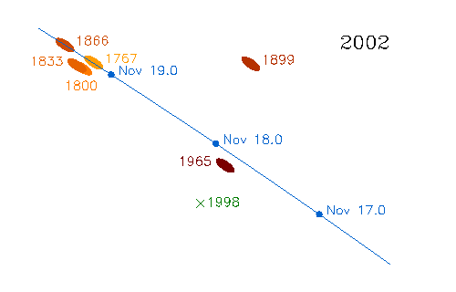
This is the famous "dust-trail-theory" figure of David Asher and Rob McNaught which expains why and when earth will move
through the Leonid dustclouds.
Note earth will pass the outer regions of the 1767 (7 revolutions) dust-trail on november 19 at 4 UT. This outburst will be visible from western Europe.
At about 10h36m earth will pass the 1866 (4 revolutions) dust-trail. To observe meteors from this dust-trail the US is the place to be.
Please consult the website of Armagh Observatory for more detailed information.
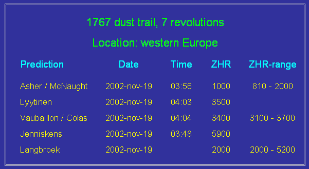
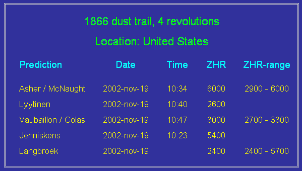
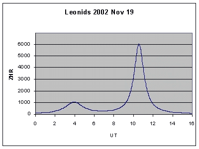
These are the famous figures of Esko Lyytinen which shows the expected ZHR observers will experience on november 19 when
the earth passes the 7-th revolution dust trail at 04:00 visible above western Europe and the 4-th revolution dust trail at 10:36 UT visible
above the United States. Note the actual hourly rate observed is (much) lower as indicated in this graph because the Leonid radiant is not
in the Zenit at most locations and the full moon will prevent fainter Leonids from beiing observed.
For detailed information please consult: Lyytinen's Team Leonid predictions for year 2002
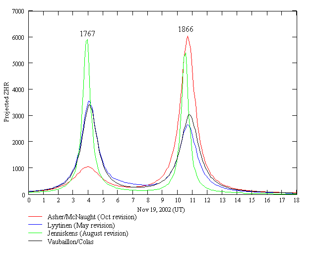
2002 Leonid Forecasts. Creation year of streams are indicated over activity peaks
by Bill Cooke, E-Mail: bill.cooke@msfc.nasa.gov
Space Environments Team, Marshall Space Flight Center
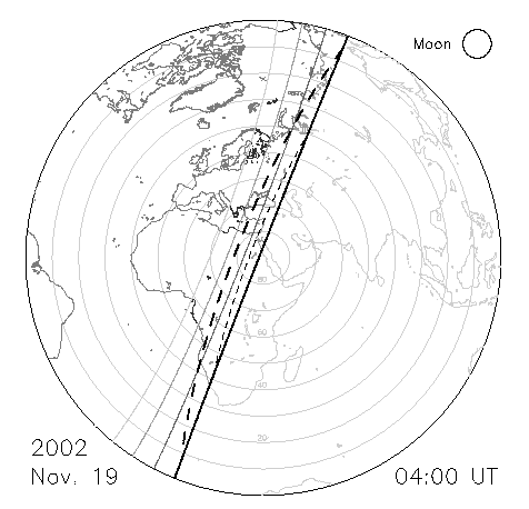
This fine figure by Rob McNaught very clearly explains where to watch the 7 revolutions (year 1767) dust trail of
the Leonids. Note the thick line from top to bottom marks the locations where the sun will rise november 19 at 04:00 UT. The thinner lines to the
left indicate the start of civil, nautical and astronomical twilight at 04:00 UT.
In the center of this figure the Leonid radiant is at the zenit. At each circle away from the center the Leonid radiant is at a 10 degrees
lower position at the sky. So roughly the radiant will be at 50 to 60 degrees elevation for most observers located in western Europe.
This figure above by Rob McNaught from the Research School of Astronomy and Astrophysics
explains in a nutshell where you have to go to observe the Leonid outburst in november 2002.
 ASTRONOMICAL SOCIETY OF AUSTRALIA
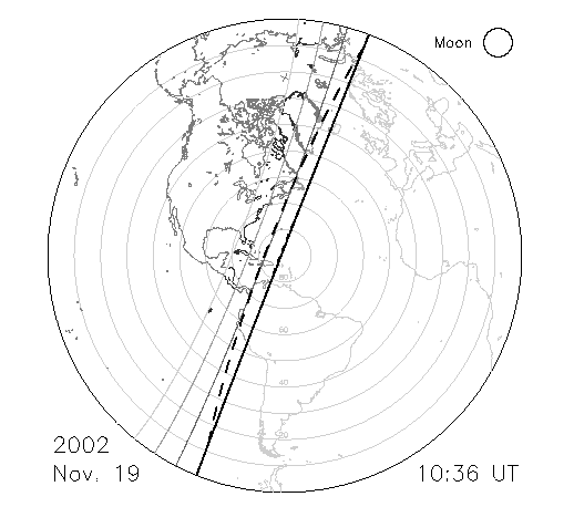
This fine figure by Rob McNaught very clearly explains where to watch the 4 revolutions dust trail (year 1866) of the
Leonids. Note the thick line from top to bottom marks the locations where the sun will rise november 19 at 10:36 UT. The thinner lines to the left
indicate the start of civil, nautical and astronomical twilight at 10:36 UT.
In the center of this figure the Leonid radiant is at the zenit. At each circle away from the center the Leonid radiant is at a 10 degrees
lower position at the sky. So roughly the radiant will be at 40 to 70 degrees elevation for most observers located in the United States.
This figure above by Rob McNaught from the Research School of Astronomy and Astrophysics
explains in a nutshell where you have to go to observe the Leonid outburst in november 2002.
Please consult the Dutch National Weather Service (KNMI) for more detailed climatological information
Please consult the Dutch National Weather Service (KNMI) for more detailed climatological information
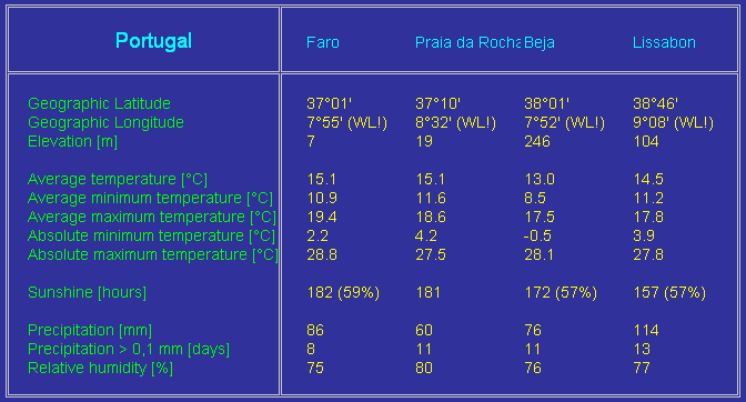
Please consult the Dutch National Weather Service (KNMI) for more detailed climatological information
The DMS Leonid Expedition 2002 to Spain and Portugal consists of:
- Team Castillejar
- Jos Nijland
- Karin Nijland-Opdenkelder
- Niek Nijland
- Arnold Tukkers
- Elise Tukkers-IJland
- Brian Tukkers
- Demi Tukkers
- Gerard de Boer
- Wytze Slofstra
- Rina Slofstra
- Team Galera
- Dani�l van Os
- Mirjam Bouwman
- Selma Koelers
- Johan Lezwijn
- Edo van Zanten
- Arthur Wiegman
- Remco Scheepmaker
- Team Otura
- Carl Johannink
- Marco Langbroek
- Rita Verhoef
- Romke Schievink
- Casper ter Kuile
- Team Calar Alto (provisional!)
- Robert Haas
- Michel Vandeputte
- Hans Huyghe
- Simon Vanderkerken
- Willy Boens
- Javor Kac
- Jure Zakrajsek
- Jure Atanackov
- Dunja Fabjan
- Nina Lampic
- Fred Kamphues
- 2
- 3
- 4
- Team Camper 1 : Curica (near to Galera)
- Hans Betlem
- Pavel Spurny
- Anna Spurny
- Team Camper 2 : Lucainena (in the Sierra Nevada)
- Jiri Borovicka
- Steve Evans
- Rob Sanders
- Team Portugal
- Koen Miskotte
- Jaap van 't Leven
- Peter Bus
- Olga van Mil
| Day | Date | Description of Activity |
|---|---|---|
| 1 | Saturday november 16 | Arrival at Malaga and transfer to observing sites |
| 2 | Sunday november 17 | Briefing at Castillejar and exchange of equipment and phonenumbers |
| 2/3 | Sunday/Monday november 17/18 | Setup and Testing equipment, observing, near-real time flux experiment |
| 3/4 | Monday/Tuesday november 18/19 | Night of the ourburst! Visual including flux, Photo, Video |
| 4 | Tuesday november 19 | Rest, preparing reports |
| 5 | Wednesday november 20 | Post meeting at Castillejar and exchange of equipment |
| 6 | Thursday november 21 | Visit to Granada |
| 7 | Friday november 22 | Preparing for departure |
| 8 | Saturday november 23 | Flight from Malaga to Amsterdam |
| 1 | Exchange of equipment to stations Castillejar, Otura and Calar Alto |
| 2 | Exchange of GSM prepaid Spanish phonenumbers for connections between the teams at local rates |
| 3 | Exchange of aiming points for the multistation image intensified videosystems |
| 4 | Checking of DCF-clocks and GPS timing accuracy |
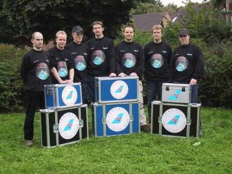
| 5 | Groupphoto of all observers and all equipment |
| 6 | Discussing the weather prospect and if necessary planning crash-expedition to clear skies... |
| 7 | Coffee and some delicious titbits :-) |
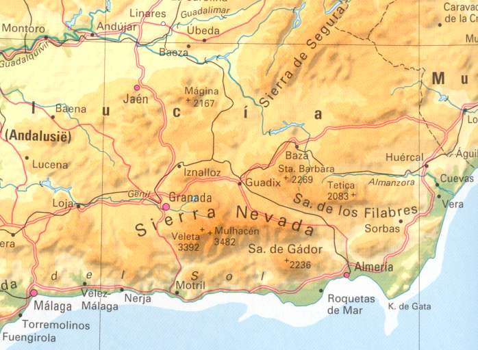
| Location | Longitude (west!) [dd.mm.ss] | Latitude (north) [dd.mm.ss] | Altitude [m] |
|---|---|---|---|
| Otura | 3 37 50 | 37 05 26 | 792 |
| Castillejar | 2 38 38 | 37 43 03 | 1000 |
| Calar Alto | 2 32 46 | 37 13 25 | 2168 |
Within Spain we make you of Spanish prepaid SIM-cards to operate our mobile phones. These phonenumbers will be exchanged between the teams at the briefing at Castillejar on sunday 17 november.
Moreover we will have available our own GSM-numbers which are operational throughout Europe. These will be used to communicate to other observers outside Spain.
| Station | GSM phonenumber |
|---|---|
| Otura-1 | +31 - 6 - 24 24 24 45 |
| Otura-2 | +31 - 6 - 47 47 62 08 |
The DMS Leonid Expedition 2002 to Spain and Portugal use visual, photographic and image intensified video techniques to observe the Leonid meteorstorm.
- Team Castillejar
- Visual: 4 observers
- Multistation photosystem
- Hazenarray: consisting of 11 Canon T-70 and 1.8/50 mm lenses, stopped down to 2.8
- Exposure and transport: fully automatic using a Canon Command Back 70
- 6 blade sector rotating at 12.5 rpm yielding 75 breaks per second
- Film: Kodak Tri-X 400
- Exposuretime: 5 minutes
- Multistation videosystem
- Optics: Canon 1.2/55 mm aspherical lens
- Image intensifier: AEG XX1400 second generation tube, 25 mm photocathode
- Digital camcorder: Panasonic NV-DS5 using 60 minutes mini DV tapes
- Team Galera
- Visual: 2 observers
- Photo: some camera's on tripods, not multistation
- Team Otura
- Visual: 3 observers
- Multistation photosystem
- Hazenarray: consisting of 11 Canon T-70 and 1.8/50 mm lenses, stopped down to 2.8
- Exposure and transport: fully automatic using a Canon Command Back 70
- 6 blade sector rotating at 12.5 rpm yielding 75 breaks per second
- Film: Kodak Tri-X 400
- Exposuretime: 5 minutes
- Low pointing multistation photosystem
- Camera's: about 4 Canon T-70 and 17, 24 and 28 mm wide angle lenses
- Exposure and transport: fully automatic by using Canon Command Back 70's
- Film: Kodak Tri-X 400
- Exposuretime: 5 minutes
- Multistation videosystem
- Optics: Canon 1.2/50 mm lens
- Image intensifier: Mullard XX1332 second generation tube, 48.8 mm photocathode
- Digital camcorder: Panasonic NV-DA1 using 60 minutes mini DV tapes
- All-sky videosystem
- Optics: Canon 1.4/24 mm lens
- Image intensifier: Mullard XX1332 second generation tube, 48.8 mm photocathode
- Digital camcorder: Sharp VL-PD6 using 60 minutes mini DV tapes
- Meteortrain videosystem
- Optics: ???
- Image intensifier: ???
- Digital camcorder: ???
- Team Calar Alto (still provisional!!!)
- Visual: 7 observers using the near real-time flux experiment of Dr. Peter Jenniskens. The system fully automatically counts observed meteors and sends the counts to the NASA datagathering system.
- Multistation photosystem
- Hazenarray: consisting of 11 Canon T-70 and 1.8/50 lenses, stopped down to 2.8
- Exposure and transport: fully automatic using a Canon Command Back 70
- 6 blade sector rotating at 12.5 rpm yielding 75 breaks per second
- Film: Kodak Tri-X 400
- Exposuretime: 5 minutes
- Low pointing multistation photosystem
- Camera-array: consisting of about 4 Canon T-70 and wide angle lenses
- Exposure and transport: fully automatic using the command back of the Hazenarray
- No sector will be in use
- Film: Kodak Tri-X 400
- Exposuretime: 5 minutes
- Photosystem
- Camera-array consisting of 5 Canon T-70 and 4 x 1.8/50 and 1 x 2.8/24 mm lenses. (Hans Huyghe)
- Multistation videosystem
- Optics: Canon ??? lens
- Image intensifier: Mullard XX1332 second generation tube, 48.8 mm photocathode
- Digital camcorder: Panasonic NV-DA1 using 60 minutes mini DV tapes
- Meteortrain videosystem
- Optics: Canon ??? lens
- Image intensifier: Mullard XX1332 second generation tube, 48.8 mm photocathode
- Digital camcorder: Sharp VL-PD3A using 60 minutes mini DV tapes
- Team Camper 1
- Multistation photosystem: 3 Camera-array's totalling 23 Canon T-70 camera's with 1.8/50 mm lenses covering the entire sky
- Multistation image intensified videosystem
- Image intensified all-sky video system to acquire timings of photographed meteors
- Team Camper 2
- Multistation photosystem: 3 Camera-array's totalling 23 Canon T-70 camera's with 1.8/50 mm lenses covering the entire sky
- Multistation image intensified videosystem
- Team Portugal
- Visual: 4 observers
- Photo: ???
- Video: ???
| Station | Name of Station | North [dd.mm.ss,s] | East [dd.mm.ss,s] | Altitude [m] |
|---|---|---|---|---|
| 1 | Rodalquilar (Otura) | 36 51 21,8 | -2 00 53,6 | 16 |
| 2 | Fuente Alamo (Castillejar) | 37 45 16,8 | -1 08 46,6 | 50? |
| 3 | Fuente Amarga (Calar Alto) | 37 30 18 | -1 58 51 | 750 |
| Night | Tape no. | Start [UT] | End [UT] |
|---|---|---|---|
| 18/19 | 1 | 02:04 | 03:54 |
| 2 | 03:56 | 05:20 |
| Night | Tape no. | Start [UT] | End [UT] |
|---|---|---|---|
| 18/19 | 1 | - | - |
| 2 | - | - | |
| 3 | - | - |
| Night | Tape no. | Start [UT] | End [UT] |
|---|---|---|---|
| 18/19 | 1 | 23:16 | 01:27 |
| 2 | 01:40 | 03:43 | |
| 3 | 03:45 | 05:32 |
Aiming points as calculated by Marc de Lignie's QRicht program:

Height of aiming point: 110 km

Geographical latitude of aiming point:  37 45'  0"
Geographical longitude of aiming point: -1 30'  0"

Geographical latitude of station 1:     36 51' 22"
Geographical longitude of station 1:    -2  0' 54"

Geographical latitude of station 2:     37 45' 17"
Geographical longitude of station 2:    -1  8' 47"

Geographical latitude of station 3:     37 30' 18"
Geographical longitude of station 3:    -1 58' 51"

Azimuth for station 1:    204.5
Elevation for station 1:   45.2

Azimuth for station 2:     89.0
Elevation for station 2:   74.2

Azimuth for station 3:    237.2
Elevation for station 3:   65.4

Julian Day  2452597.5 corresponds to date 11-19-2002

    JD     time(UT)    RA1    DE1     RA2    DE2     RA3    DE3

           17:00:00    0 38  69 50   19 31  35 50   22 50  47 05
           18:00:00    1 38  69 50   20 31  35 50   23 50  47 05
           19:00:00    2 38  69 50   21 31  35 50    0 50  47 05
           20:00:00    3 38  69 50   22 32  35 50    1 50  47 05
           21:00:00    4 39  69 50   23 32  35 50    2 50  47 05
           22:00:00    5 39  69 50    0 32  35 50    3 51  47 05
           23:00:00    6 39  69 50    1 32  35 50    4 51  47 05
2452598.5   0:00:00    7 39  69 50    2 32  35 50    5 51  47 05
            1:00:00    8 39  69 50    3 32  35 50    6 51  47 05
            2:00:00    9 39  69 50    4 32  35 50    7 51  47 05
            3:00:00   10 40  69 50    5 33  35 50    8 51  47 05
            4:00:00   11 40  69 50    6 33  35 50    9 52  47 05
            5:00:00   12 40  69 50    7 33  35 50   10 52  47 05
            6:00:00   13 40  69 50    8 33  35 50   11 52  47 05


Angles between average trails of active major streams:

Stream              time(UT)     1-2     1-3     2-3

Leonids
                    17:00:00      46       5      41
                    18:00:00      39       1      40
                    19:00:00      29       7      36
                    20:00:00      16      13      29
                    21:00:00       3      18      21
                    22:00:00       9      23      14
                    23:00:00      21      27       6
                     0:00:00      31      31       0
                     1:00:00      42      35       7
                     2:00:00      53      36      17
                     3:00:00      62      32      31
                     4:00:00      70      19      51
                     5:00:00      74       1      73
                     6:00:00      71      13      84


A minus sign indicates that the angle varies strongly across the
field of either station (close to radiant).